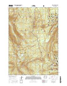
2017 Map of Devils Peak
USGS Topo · Published 2017About this map
Devils Peak and the high ridges of the Southern Cascades define this landscape within the Rogue River National Forest and Winema National Forest. The Pacific Crest National Scenic Trail winds along a north-south spine, connecting notable summits such as Maude Mtn, Ethel Mtn, and Lee Peak. The geography is characterized by distinct alpine basins, most notably the Seven Lakes Basin, which contains a cluster of water bodies including North Lake, South Lake, and Lake Alta.
Find a feature on this map
55 named features on this map. Tap any name to fly to it.
Don’t see what you’re looking for? This feature index may not catch every label — zoom into the map to look around manually.
Map Details
Editions of this 2017 Devils Peak Map
This is the sole edition of this map. No revisions or reprints were ever made.
Other maps of this area

1891 · Ashland
USGS Topo · 1:250,000

1893 · Ashland
USGS Topo · 1:250,000

1897 · Ashland
USGS Topo · 1:250,000

1955 · Rustler Peak
USGS Topo · 1:62,500

1955 · Pelican Butte
USGS Topo · 1:62,500

1955 · Medford
USGS Topo · 1:250,000

1956 · Prospect
USGS Topo · 1:62,500

1957 · Medford
USGS Topo · 1:250,000

1958 · Medford
USGS Topo · 1:250,000
1985 · Rustler Peak
USGS Topo · 1:24,000