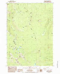
1985 Map of Devils Peak
USGS Topo · Published 1985About this map
Devils Peak and Lee Peak anchor the southern reaches of this 1980s mountain survey, where the Rogue River National Forest meets the Winema National Forest. The landscape is dominated by high-elevation hydrology, centered on the Seven Lakes Basin which includes South Lake, North Lake, and Middle Lake. This area was documented during a period of transition in forest management and recreation, as evidenced by the route of the Pacific Crest National Scenic Trail winding through the center of the quadrangle. To the north, the terrain gives way to the open Oregon Desert and expansive grazing areas like Mc Kie Meadow and Solace Meadow. Numerous named water sources, such as Crippled Horse Spring and Big Foot Spring, indicate a reliance on specific points of water for both wildlife and human activity in this volcanic landscape.
Find a feature on this map
52 named features on this map. Tap any name to fly to it.
Don’t see what you’re looking for? This feature index may not catch every label — zoom into the map to look around manually.
Map Details
Editions of this 1985 Devils Peak Map
This is the sole edition of this map. No revisions or reprints were ever made.
Other maps of this area

1891 · Ashland
USGS Topo · 1:250,000

1893 · Ashland
USGS Topo · 1:250,000

1897 · Ashland
USGS Topo · 1:250,000

1955 · Rustler Peak
USGS Topo · 1:62,500

1955 · Pelican Butte
USGS Topo · 1:62,500

1955 · Medford
USGS Topo · 1:250,000

1956 · Prospect
USGS Topo · 1:62,500

1957 · Medford
USGS Topo · 1:250,000

1958 · Medford
USGS Topo · 1:250,000
1985 · Rustler Peak
USGS Topo · 1:24,000