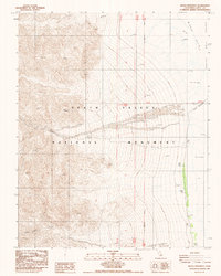
1988 Map of Devils Speedway
USGS Topo · Published 1988About this map
Death Valley National Monument reveals a stark, arid landscape where high desert peaks descend into the low-lying reaches of the Basin. This 1988 survey focuses on the unique corridor of the Devils Speedway, an unpaved route cutting across the floor toward the Middle Course. The terrain is characterized by massive alluvial fans emerging from Trail Canyon and Death Valley Canyon, which spill into the expansive Salt Flat and areas of Mud And Alkali. This map highlights the precarious balance of desert travel, marking a high-clearance 4wd Trail as the primary means of navigating the western slopes. Surveyed just before the area's designation was changed to a National Park, the map documents the administrative boundaries of the San Bernardino Meridian and the complex topography of one of the lowest points in North America.
Find a feature on this map
15 named features on this map. Tap any name to fly to it.
Don’t see what you’re looking for? This feature index may not catch every label — zoom into the map to look around manually.
Map Details
Editions of this 1988 Devils Speedway Map
This is the sole edition of this map. No revisions or reprints were ever made.
Other maps of this area

1908 · Furnace Creek
USGS Topo · 1:250,000

1908 · Ballarat
USGS Topo · 1:250,000

1910 · Furnace Creek
USGS Topo · 1:250,000

1913 · Ballarat
USGS Topo · 1:250,000

1948 · Death Valley
USGS Topo · 1:250,000

1952 · Furnace Creek
USGS Topo · 1:62,500

1952 · Bennetts Well
USGS Topo · 1:62,500

1952 · Telescope Peak
USGS Topo · 1:62,500

1952 · Emigrant Canyon
USGS Topo · 1:62,500

1954 · Death Valley
USGS Topo · 1:250,000