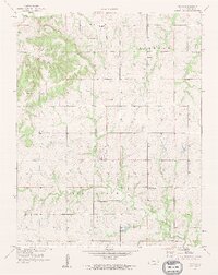
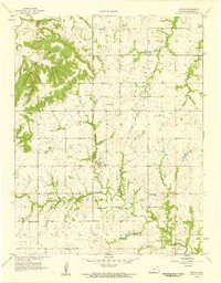
1958 Map of Devon
USGS Topo · Published 1959About this map
Devon and the surrounding Bourbon County countryside are defined by a network of rural schools and churches that anchored this Kansas community in the late 1950s. The landscape is split between the northern timbered elevations of Timber Hill and Freedom, and the fertile bottomlands of Mill Creek to the south. A prominent Old Railroad Grade cuts north-to-south through the center of the sheet, passing through Harding and Devon, marking the path of former rail commerce that once supported the local agricultural economy.
Find a feature on this map
21 named features on this map. Tap any name to fly to it.
Don’t see what you’re looking for? This feature index may not catch every label — zoom into the map to look around manually.
Map Details
Editions of this 1958 Devon Map
2 editions found
Other maps of this area

1884 · Fort Scott
USGS Topo · 1:125,000

1886 · Fort Scott
USGS Topo · 1:125,000

1887 · Mound City
USGS Topo · 1:125,000

1893 · Fort Scott
USGS Topo · 1:125,000

1893 · Mound City
USGS Topo · 1:125,000

1947 · Lawrence
USGS Topo · 1:250,000

1947 · Joplin
USGS Topo · 1:250,000

1949 · Joplin
USGS Topo · 1:250,000

1950 · Lawrence
USGS Topo · 1:250,000

1954 · Joplin
USGS Topo · 1:250,000