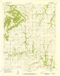
1958 Map of Devon
USGS Topo · Published 1959About this map
Devon and Harding serve as the primary anchors of this Bourbon County landscape during the late 1950s. The region is defined by a dense network of rural community institutions, including several country schools such as Fish Creek Sch and Fairmount Sch, alongside multiple local burial grounds like Avondale Cem and West Plains Cem. The terrain is marked by the prominent elevations of Timber Hill and Freedom, which overlook the winding course of the Little Osage River to the north and the expansive drainage of Mill Creek to the south. An interesting remnant of earlier infrastructure is the Old Railroad Grade that cuts through the southern portion of the quadrangle near Centerville Ch. This transition from active rail to an established grade reflects the shifting transportation priorities of the mid-20th century in eastern Kansas.
Find a feature on this map
19 named features on this map. Tap any name to fly to it.
Don’t see what you’re looking for? This feature index may not catch every label — zoom into the map to look around manually.
Map Details
Editions of this 1958 Devon Map
2 editions found
Other maps of this area

1884 · Fort Scott
USGS Topo · 1:125,000

1886 · Fort Scott
USGS Topo · 1:125,000

1887 · Mound City
USGS Topo · 1:125,000

1893 · Fort Scott
USGS Topo · 1:125,000

1893 · Mound City
USGS Topo · 1:125,000

1947 · Lawrence
USGS Topo · 1:250,000

1947 · Joplin
USGS Topo · 1:250,000

1949 · Joplin
USGS Topo · 1:250,000

1950 · Lawrence
USGS Topo · 1:250,000

1954 · Joplin
USGS Topo · 1:250,000