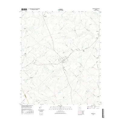
2017 Map of Dexter
USGS Topo · Published 2017About this map
Dexter and the surrounding agricultural lands of Laurens County define this landscape, where a network of county roads connects several small settlements. The area is characterized by a dense system of creeks and branches, including the prominent Stitchihatchie Creek and Rocky Creek, which feed into local water bodies like Nesmith Lake and Malone Lake. Several bridges, such as Buckhorn Bridge and Spring Haven Bridge, serve as vital crossing points throughout the drainage basin. Local history and genealogy researchers can find several established burial grounds, including Saint Lukes Cemetery, Mount Carmel Cemetery, and Alligood Cemetery. The map also illustrates the transition between Laurens and Dodge counties, showing how the rural road system, like Co RD 257, links communities such as Alcorns, Rentz, and Five Points.
Find a feature on this map
107 named features on this map. Tap any name to fly to it.
Don’t see what you’re looking for? This feature index may not catch every label — zoom into the map to look around manually.
Map Details
Editions of this 2017 Dexter Map
This is the sole edition of this map. No revisions or reprints were ever made.
Other maps of this area

1957 · Macon
USGS Topo · 1:250,000

1958 · Macon
USGS Topo · 1:250,000

1964 · Macon
USGS Topo · 1:250,000

1973 · Cadwell
USGS Topo · 1:24,000

1974 · Chester
USGS Topo · 1:24,000

1974 · Danville East
USGS Topo · 1:24,000

1974 · Five Points
USGS Topo · 1:24,000

1974 · Rentz
USGS Topo · 1:24,000

1974 · Dudley
USGS Topo · 1:24,000
1974 · Yonkers
USGS Topo · 1:24,000