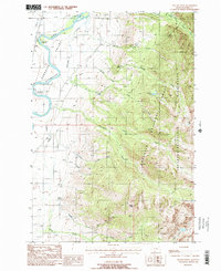
1988 Map of Dexter Point
USGS Topo · Published 1988About this map
The Yellowstone River snakes through the western portion of Paradise Valley in this late-1980s landscape, where the valley floor transitions into the steep slopes of the Gallatin National Forest and the Absaroka-Beartooth Wilderness. The map captures a detailed view of local infrastructure such as the Paradise Canal and the Old Railroad Grade, reflecting the area's agricultural and transportation history. Small-scale human presence is documented through the Magee Cemetery and Shorty Cemetery, alongside recreational hubs like Loch Leven Campground and Pine Creek Campground. Rising from the drainage of Magee Creek and Kauffman Creek, the terrain culminates at the eponymous Dexter Point. The map also highlights natural landmarks such as Cascade Falls and several small alpine bodies like Fire Lake, illustrating the complex drainage network of Pine Creek and its many forks.
Find a feature on this map
32 named features on this map. Tap any name to fly to it.
Don’t see what you’re looking for? This feature index may not catch every label — zoom into the map to look around manually.
Map Details
Editions of this 1988 Dexter Point Map
This is the sole edition of this map. No revisions or reprints were ever made.
Other maps of this area

1891 · Livingston
USGS Topo · 1:250,000

1893 · Livingston
USGS Topo · 1:250,000

1940 · Mt. Cowen
USGS Topo · 1:62,500

1943 · Mt Cowen
USGS Topo · 1:62,500

1947 · Bozeman
USGS Topo · 1:250,000

1948 · Bozeman
USGS Topo · 1:250,000

1951 · Brisbin
USGS Topo · 1:24,000

1951 · Livingston Peak
USGS Topo · 1:24,000

1951 · Chimney Rock
USGS Topo · 1:24,000

1955 · Bozeman
USGS Topo · 1:250,000