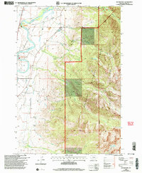
2000 Map of Dexter Point
USGS Topo · Published 2005About this map
Paradise Valley is defined by the sweeping course of the Yellowstone River, which serves as the primary corridor for settlement and recreation in this part of Park County. This survey reveals a landscape where the river's Western bank provides access at the Mallards Rest Recreation Area and Loch Leven Recreation Area, while the rugged Eastern terrain quickly ascends into the Gallatin National Forest. Genealogy researchers can locate family sites at the Shorthill Cemetery and Magee Cemetery, which sit on the benches above the river plain. The map captures the abrupt transition from the irrigated valley floor to the high elevations of the Absaroka-Beartooth Wilderness, where features like Dexter Point and Cascade Falls mark the interior of the Beartooth range. Small local developments like Luccock Park are shown alongside infrastructure such as Gravel Pits and various creek drainages including McDonald Creek.
Find a feature on this map
27 named features on this map. Tap any name to fly to it.
Don’t see what you’re looking for? This feature index may not catch every label — zoom into the map to look around manually.
Map Details
Editions of this 2000 Dexter Point Map
This is the sole edition of this map. No revisions or reprints were ever made.
Other maps of this area

1891 · Livingston
USGS Topo · 1:250,000

1893 · Livingston
USGS Topo · 1:250,000

1940 · Mt. Cowen
USGS Topo · 1:62,500

1943 · Mt Cowen
USGS Topo · 1:62,500

1947 · Bozeman
USGS Topo · 1:250,000

1948 · Bozeman
USGS Topo · 1:250,000

1951 · Brisbin
USGS Topo · 1:24,000

1951 · Livingston Peak
USGS Topo · 1:24,000

1951 · Chimney Rock
USGS Topo · 1:24,000

1955 · Bozeman
USGS Topo · 1:250,000