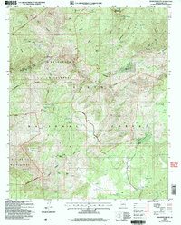
2004 Map of Diamond Butte
USGS Topo · Published 2006About this map
Ellison Mine and several scattered ranch sites anchor this portion of the Tonto National Forest in the mid-2000s. The landscape is defined by the sharp descent into the Hellsgate Wilderness, where the deep drainage of Tonto Creek meets its many tributaries, including Haigler Creek and Gordon Canyon. Cattle-raising history is evident in the prevalence of water management features like Fuller Mesa Tank and Marsh Creek Tank, supporting operations at Ellinwood Ranch and Marsh Creek Ranch. High points like Diamond Butte and Oxbow Mountain overlook a complex network of draws and ridges, including Apache Ridge and Board Cabin Draw, illustrating the rugged topography that necessitated the remote outposts of Winter Camp and various prospect sites.
Find a feature on this map
89 named features on this map. Tap any name to fly to it.
Don’t see what you’re looking for? This feature index may not catch every label — zoom into the map to look around manually.
Map Details
Editions of this 2004 Diamond Butte Map
This is the sole edition of this map. No revisions or reprints were ever made.
Other maps of this area

1886 · Holbrook
USGS Topo · 1:250,000

1887 · Verde
USGS Topo · 1:250,000

1892 · Verde
USGS Topo · 1:250,000

1893 · Holbrook
USGS Topo · 1:250,000

1934 · Promontory Butte
USGS Topo · 1:62,500

1937 · Diamond Butte
USGS Topo · 1:48,000

1939 · Promontory Butte
USGS Topo · 1:62,500

1943 · Diamond Butte
USGS Topo · 1:62,500

1952 · Promontory Butte
USGS Topo · 1:62,500

1954 · Holbrook
USGS Topo · 1:250,000