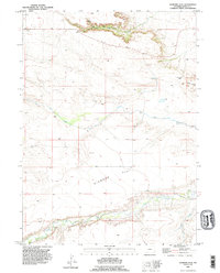
1990 Map of Diamond Flat
USGS Topo · Published 1995About this map
Diamond Flat characterizes this high-plains landscape in southeastern Wyoming, where the terrain is defined by a series of dramatic breaks and winding watercourses. This map, revised in 1990 from late 1950s imagery, reveals the essential geography of Goshen County before modern development altered the vast ranching tracts. To the north, the sharp incision of Lone Tree Canyon cuts through the uplands, while distinctive geological landmarks like Castle Rocks and the Fox Creek Gap provide natural orientation points for travelers and local residents. The drainage patterns of Fox Creek and Bear Creek dictate the movement of livestock and the placement of remote homesteads, including the small settlement of Wilkins. For genealogists and land researchers, the intricate network of fence and field lines recorded here offers a rare look at the 20th-century division of this open cattle country.
Find a feature on this map
12 named features on this map. Tap any name to fly to it.
Don’t see what you’re looking for? This feature index may not catch every label — zoom into the map to look around manually.
Map Details
Editions of this 1990 Diamond Flat Map
This is the sole edition of this map. No revisions or reprints were ever made.
Other maps of this area

1899 · Goshen Hole
USGS Topo · 1:125,000

1954 · Cheyenne
USGS Topo · 1:250,000

1958 · Cheyenne
USGS Topo · 1:250,000

1960 · Diamond Flat
USGS Topo · 1:24,000

1960 · Hawk Springs
USGS Topo · 1:24,000

1960 · Needle Rock
USGS Topo · 1:24,000

1960 · Rocky Hollow
USGS Topo · 1:24,000

1960 · Kessler Gap
USGS Topo · 1:24,000

1960 · Meriden
USGS Topo · 1:24,000

1963 · Y B O Canyon
USGS Topo · 1:24,000