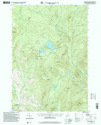
1996 Map of Diamond Pond
USGS Topo · Published 2000About this map
Coleman State Park sits at the heart of this landscape in Coos County, where the borders of Clarksville, Stewartstown, and Colebrook converge. The terrain is defined by a dense network of mountain ridges and water bodies, including Diamond Pond and its smaller neighbor Little Diamond Pond, which feed the Swift Diamond River. To the southwest, the headwaters of the Mohawk River emerge near the settlements of Kidderville and Upper Kidderville.
Find a feature on this map
52 named features on this map. Tap any name to fly to it.
Don’t see what you’re looking for? This feature index may not catch every label — zoom into the map to look around manually.
Map Details
Editions of this 1996 Diamond Pond Map
This is the sole edition of this map. No revisions or reprints were ever made.
Other maps of this area

1925 · Indian Stream
USGS Topo · 1:48,000

1926 · Indian Stream
USGS Topo · 1:62,500

1927 · Indian Stream
USGS Topo · 1:62,500

1927 · Second Lake
USGS Topo · 1:62,500

1930 · Dixville
USGS Topo · 1:62,500

1930 · Errol
USGS Topo · 1:62,500

1932 · Second Lake
USGS Topo · 1:62,500

1933 · Dixville
USGS Topo · 1:62,500

1934 · Dixville
USGS Topo · 1:62,500

1934 · Errol
USGS Topo · 1:62,500