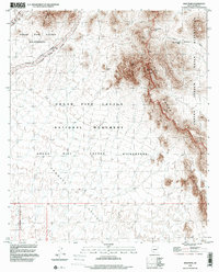
1996 Map of Diaz Peak
USGS Topo · Published 2000About this map
The Ajo Range dominates this portion of the Sonoran Desert, where the steep ridgeline forms a natural boundary between the Tohono O'odham Indian Reservation and the protected lands of the Organ Pipe Cactus National Monument. This high-elevation desert landscape features prominent summits like Diaz Peak and the nearby Diaz Spire, overlooking the broad expanse of the Sonoyta Valley. The drainage patterns of the Shuatak Wash and the narrow corridors of Sweetwater Pass and Siovi Shuatak Pass illustrate how water and movement are channeled through this arid environment. Evidence of human adaptation and land management is seen in labels for the Cement Tank and the strictly defined Wilderness Boundary that carves through the Diablo Mountains. The infrastructure of the park is represented by the Ajo Mountain One Way Drive, providing access to the foot of the Sierra De Santa Rosa.
Find a feature on this map
18 named features on this map. Tap any name to fly to it.
Don’t see what you’re looking for? This feature index may not catch every label — zoom into the map to look around manually.
Map Details
Editions of this 1996 Diaz Peak Map
This is the sole edition of this map. No revisions or reprints were ever made.
Other maps of this area

1953 · Ajo
USGS Topo · 1:250,000

1954 · Sonoyta
USGS Topo · 1:250,000

1957 · Ajo
USGS Topo · 1:250,000

1958 · Ajo
USGS Topo · 1:250,000

1962 · Ajo
USGS Topo · 1:250,000

1963 · Ajo
USGS Topo · 1:250,000

1963 · Mt. Ajo
USGS Topo · 1:62,500

1963 · Lukeville
USGS Topo · 1:62,500

1963 · Kino Peak
USGS Topo · 1:62,500

1963 · Lukeville
USGS Topo · 1:250,000