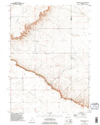
1990 Map of Dickinson Hill
USGS Topo · Published 1995About this map
The Goshen Hole Rim forms a dramatic geographical boundary across this section of eastern Wyoming, separating the elevated Slater Flats from the lower basin of Goshen Hole. This 1990 revision, based on surveys dating back to 1958, illustrates a landscape defined by water management and ranching operations. The Dickinson Hill promontory stands as a central landmark above the rim, while the sparse settlement pattern is anchored by locations such as the Baker Ranch and Swan. The map reveals the infrastructure of the high plains, including a Pumping Station and an extensive Pipeline system, alongside natural water sources like Mud Springs and Forney Springs. The border between Platte and Goshen counties bisects the eastern portion of the sheet, cutting through the drainage of Forney Draw.
Find a feature on this map
17 named features on this map. Tap any name to fly to it.
Don’t see what you’re looking for? This feature index may not catch every label — zoom into the map to look around manually.
Map Details
Editions of this 1990 Dickinson Hill Map
This is the sole edition of this map. No revisions or reprints were ever made.
Other maps of this area

1896 · Hartville
USGS Topo · 1:125,000

1901 · Hartville
USGS Topo · 1:125,000

1950 · Rockeagle
USGS Topo · 1:24,000

1951 · Antelope Gap
USGS Topo · 1:24,000

1951 · Eagles Nest
USGS Topo · 1:24,000

1953 · Chugwater
USGS Topo · 1:24,000

1953 · Bordeaux
USGS Topo · 1:24,000

1954 · Torrington
USGS Topo · 1:250,000

1954 · Cheyenne
USGS Topo · 1:250,000

1958 · Cheyenne
USGS Topo · 1:250,000