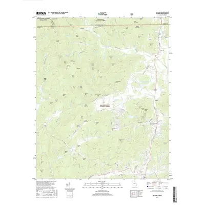
2017 Map of Dillard
USGS Topo · Published 2017About this map
The Tennessee Valley Divide snakes through this high mountain corridor where the Nantahala National Forest meets the Chattahoochee National Forest. This section of Rabun County is characterized by a concentrated string of settlements including Dillard, Mountain City, and Clayton situated along the valley floor. The geography here is defined by sharp peaks and gaps, such as Wolf Fork Gap and Patterson Gap, which have historically dictated the placement of roads like Wolf Fork Rd and the Appalachian National Scenic Trail. Traces of local industry and early community life appear via Kilby Mill and Dickerson Mill, while the Rabun Gap Nacoochee School Lake points to long-standing educational institutions. Genealogists will find several burial grounds mapped, including Wesley Chapel Cem and Pickett Cem, located near the winding waters of the Little Tennessee River.
Find a feature on this map
155 named features on this map. Tap any name to fly to it.
Don’t see what you’re looking for? This feature index may not catch every label — zoom into the map to look around manually.
Map Details
Editions of this 2017 Dillard Map
This is the sole edition of this map. No revisions or reprints were ever made.
Other maps of this area

1886 · Dahlonega
USGS Topo · 1:125,000

1886 · Walhalla
USGS Topo · 1:125,000

1891 · Cowee
USGS Topo · 1:125,000

1892 · Dahlonega
USGS Topo · 1:125,000

1892 · Walhalla
USGS Topo · 1:125,000

1896 · Walhalla
USGS Topo · 1:125,000

1896 · Dahlonega
USGS Topo · 1:125,000

1897 · Cowee
USGS Topo · 1:125,000

1903 · Dahlonega
USGS Topo · 1:125,000

1907 · Cowee
USGS Topo · 1:125,000