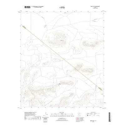
2019 Map of Dimple Hills
USGS Topo · Published 2019About this map
Sugar Loaf Mtn and the namesake Dimple Hills dominate this high-desert landscape in Trans-Pecos Texas. The terrain is defined by dramatic elevation changes and a network of ephemeral watercourses including Big Canyon, Eighty Tank Draw, and Red Mill Draw, which channel seasonal runoff through the arid basins. Evidence of ranching and land management appears in features like Eighty Tank and the level expanse of W B Flats. The map also traces the jurisdictional line between Pecos and Brewster Counties, a boundary that bisects the rugged topography. Remote access to these hills is provided by unpaved tracks such as Dimple Hill Rd and Cupolo Peak Rd, which wind through the canyons and foothills of this sparsely settled territory.
Find a feature on this map
11 named features on this map. Tap any name to fly to it.
Don’t see what you’re looking for? This feature index may not catch every label — zoom into the map to look around manually.
Map Details
Editions of this 2019 Dimple Hills Map
This is the sole edition of this map. No revisions or reprints were ever made.
Other maps of this area

1920 · Longfellow
USGS Topo · 1:125,000

1920 · Marathon
USGS Topo · 1:62,500

1921 · Marathon
USGS Topo · 1:62,500

1923 · Hess Canyon
USGS Topo · 1:62,500

1954 · Fort Stockton
USGS Topo · 1:250,000

1958 · Fort Stockton
USGS Topo · 1:250,000

1968 · Housetop Mountains
USGS Topo · 1:24,000

1968 · Cap Rock Butte
USGS Topo · 1:24,000

1968 · Marathon Gap
USGS Topo · 1:24,000

1968 · Dimple Hills
USGS Topo · 1:24,000