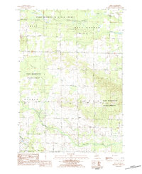
1983 Map of Dinca
USGS Topo · Published 1984About this map
Pere Marquette State Forest dominates this section of Missaukee County, where the West Branch Muskegon River meanders through the northern timberlands. The landscape transition from forest to agricultural land is marked by a grid of rural roads, including Eightmile Road and Lotan Road, which connect small crossroads like Dinca and Keelans Corner. These tiny settlements, alongside the local Townhall, represent the civic heart of the Reeder and Aetna townships during the early 1980s.
Find a feature on this map
34 named features on this map. Tap any name to fly to it.
Don’t see what you’re looking for? This feature index may not catch every label — zoom into the map to look around manually.
Map Details
Editions of this 1983 Dinca Map
This is the sole edition of this map. No revisions or reprints were ever made.
Other maps of this area

1954 · Traverse City
USGS Topo · 1:250,000

1956 · Houghton Lake
USGS Topo · 1:62,500

1956 · Lake City
USGS Topo · 1:62,500

1957 · Harrison
USGS Topo · 1:62,500

1957 · Marion
USGS Topo · 1:62,500

1958 · Traverse City
USGS Topo · 1:250,000

1983 · Cadillac
USGS Topo · 1:100,000

1983 · Moddersville
USGS Topo · 1:25,000

1983 · Stittsville
USGS Topo · 1:24,000

1983 · Lake City
USGS Topo · 1:25,000