
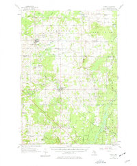
1957 Map of Marion
USGS Topo · Published 1958About this map
Marion stands as a central hub in this mid-century landscape where the Ann Arbor railroad cuts across the terrain of Marion and Middle Branch townships. This 1957 survey captures a region defined by its rural infrastructure and natural drainage, where the Clam River and its multiple branches, including the Middle Branch Clam River, shape the settlement patterns. The map documents an era of active resource extraction, evidenced by the extensive Oil and Gas Storage Field in Winterfield and numerous gravel pits scattered near Vogel Center and McBain. Genealogists will find a wealth of local markers, from the Riverside Cem to the Clark Sch (Abandoned), alongside established community centers like the Calvin Ch and the small siding at Temple near the Muskegon River.
Find a feature on this map
65 named features on this map. Tap any name to fly to it.
Don’t see what you’re looking for? This feature index may not catch every label — zoom into the map to look around manually.
Map Details
Editions of this 1957 Marion Map
2 editions found
Other maps of this area

1954 · Traverse City
USGS Topo · 1:250,000

1954 · Midland
USGS Topo · 1:250,000

1956 · Houghton Lake
USGS Topo · 1:62,500

1956 · Cadillac North
USGS Topo · 1:62,500

1956 · Lake City
USGS Topo · 1:62,500

1957 · Harrison
USGS Topo · 1:62,500

1957 · Cadillac South
USGS Topo · 1:62,500

1958 · Traverse City
USGS Topo · 1:250,000

1958 · Midland
USGS Topo · 1:250,000

1959 · Midland
USGS Topo · 1:250,000