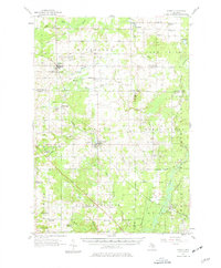
1957 Map of Marion
USGS Topo · Published 1977About this map
The Middle Branch River and Clam River converge in this mid-century survey of the northern lower peninsula, where agricultural clearings meet established state forest lands. The village of Marion sits as a central hub, while the Ann Arbor railroad line cuts a diagonal path through the landscape, connecting smaller settlements like Temple and McBain. The map reflects a rural economy shaped by natural resources, featuring the Riverside Gas Field and several oil and gas storage fields in the east.
Find a feature on this map
65 named features on this map. Tap any name to fly to it.
Don’t see what you’re looking for? This feature index may not catch every label — zoom into the map to look around manually.
Map Details
Editions of this 1957 Marion Map
2 editions found
Other maps of this area

1954 · Traverse City
USGS Topo · 1:250,000

1954 · Midland
USGS Topo · 1:250,000

1956 · Houghton Lake
USGS Topo · 1:62,500

1956 · Cadillac North
USGS Topo · 1:62,500

1956 · Lake City
USGS Topo · 1:62,500

1957 · Harrison
USGS Topo · 1:62,500

1957 · Cadillac South
USGS Topo · 1:62,500

1957 · Marion
USGS Topo · 1:62,500

1958 · Traverse City
USGS Topo · 1:250,000

1958 · Midland
USGS Topo · 1:250,000