
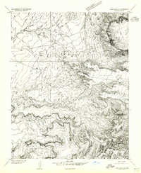
1953 Map of Dinne Mesa SE
USGS Topo · Published 1954About this map
Navajo Indian Reservation lands in Apache County dominate this 1950s topographic study, revealing a landscape defined by dramatic elevation changes and seasonal watercourses. The high plateau of Dry Mesa and the prominent Black Rock Point (Tsitah) overlook a complex system of drainage including Silt Wash and Dry Wash. To the south, the terrain drops sharply into the depths of Toh-Chin-Lini Canyon and Seklaidesa Canyon, where the intricate contour lines illustrate the erosive power of water on the Toh-Chin-Lini Mesa. Sparse human infrastructure is noted by a lone Windmill and a small Dam in the northwest, highlighting the importance of water management in this arid region. This preliminary edition captures the area's geography just as modern photogrammetric mapping began to replace older ground-survey techniques.
Find a feature on this map
11 named features on this map. Tap any name to fly to it.
Don’t see what you’re looking for? This feature index may not catch every label — zoom into the map to look around manually.
Map Details
Editions of this 1953 Dinne Mesa SE Map
2 editions found
Other maps of this area

1892 · Canyon De Chelly
USGS Topo · 1:250,000

1953 · Los Gigantes NE
USGS Topo · 1:24,000

1953 · Los Gigantes NW
USGS Topo · 1:24,000

1953 · Dinne Mesa NW
USGS Topo · 1:24,000

1953 · Pastora Peak SW
USGS Topo · 1:24,000

1953 · Pastora Peak NW
USGS Topo · 1:24,000

1953 · Dinne Mesa NE
USGS Topo · 1:24,000

1953 · Dinne Mesa SW
USGS Topo · 1:24,000

1953 · Redrock Valley NW
USGS Topo · 1:24,000

1953 · Pastora Peak
USGS Topo · 1:62,500