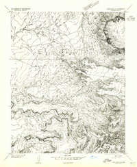
1953 Map of Dinne Mesa SE
USGS Topo · Published 1955About this map
Navajo Indian Reservation lands within Apache County are defined by deep canyon systems and prominent mesas in this mid-century topographic study. The landscape is dominated by the drainage patterns of Toh-chin-Lini Canyon and Seklagaidesa Canyon, which carve through the high elevations of Toh-chin-Lini Mesa and Dry Mesa. At the northeastern edge, Black Rock Point (Tsitah) provides a sharp landmark overlooking the basin. Human presence in this arid environment is indicated by isolated water management features like a Windmill and a Dam, supporting life near ephemeral watercourses such as Sili Wash and Tsitah Wash. The map reflects a period of transition, published as a preliminary edition during the early 1950s as broader regional surveys were being finalized.
Find a feature on this map
12 named features on this map. Tap any name to fly to it.
Don’t see what you’re looking for? This feature index may not catch every label — zoom into the map to look around manually.
Map Details
Editions of this 1953 Dinne Mesa SE Map
2 editions found
Other maps of this area

1892 · Canyon De Chelly
USGS Topo · 1:250,000

1953 · Los Gigantes NE
USGS Topo · 1:24,000

1953 · Los Gigantes NW
USGS Topo · 1:24,000

1953 · Dinne Mesa NW
USGS Topo · 1:24,000

1953 · Pastora Peak SW
USGS Topo · 1:24,000

1953 · Pastora Peak NW
USGS Topo · 1:24,000

1953 · Dinne Mesa NE
USGS Topo · 1:24,000

1953 · Dinne Mesa SW
USGS Topo · 1:24,000

1953 · Redrock Valley NW
USGS Topo · 1:24,000

1953 · Dinne Mesa SE
USGS Topo · 1:24,000