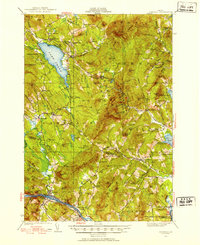
1926 Map of Dixfield
USGS Topo · Published 1953About this map
The Androscoggin River carves through the southern landscape of this 1926 survey, where the Maine Central railroad follows the riverbank past Dixfield and West Peru. To the north, Lake Webb dominates the terrain, surrounded by the high ridges of Weld and the small settlement at Weld Corner. This region is defined by a dense network of rural schoolhouses and family-named summits, illustrating a distributed settlement pattern common in the early twentieth century. Schools like Science Hill Sch and Maple Grove Sch are tucked away near timbered slopes and brook-fed meadows. The presence of Holt Mill and the expansive Siberia Meadows suggests a landscape tied to seasonal timber and agricultural production, while prominent landmarks like Whittemore Bluff and Lovejoy Mtn provide fixed reference points for this high-elevation Franklin County terrain.
Find a feature on this map
129 named features on this map. Tap any name to fly to it.
Don’t see what you’re looking for? This feature index may not catch every label — zoom into the map to look around manually.
Map Details
Editions of this 1926 Dixfield Map
2 editions found
Other maps of this area

1910 · Livermore
USGS Topo · 1:62,500

1911 · Bryant Pond
USGS Topo · 1:62,500

1911 · Buckfield
USGS Topo · 1:62,500

1912 · Livermore
USGS Topo · 1:62,500

1913 · Buckfield
USGS Topo · 1:62,500

1914 · Bryant Pond
USGS Topo · 1:62,500

1924 · Farmington
USGS Topo · 1:62,500

1926 · Dixfield
USGS Topo · 1:62,500

1927 · Rumford
USGS Topo · 1:48,000

1929 · Phillips
USGS Topo · 1:48,000