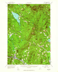
1956 Map of Dixfield
USGS Topo · Published 1962About this map
Mt Blue State Park dominates the northern landscape of this mid-century survey, where the rugged peaks of Westbrook Mountain and Potter Hill overlook the expansive Lake Webb. The settlement patterns here reflect a classic Maine transition from upland agriculture to river-valley industry. Small upland communities like Weld Corner and Berry Mills are connected by winding brooks, while the southern border is defined by the industrial corridor of the Androscoggin River.
Find a feature on this map
105 named features on this map. Tap any name to fly to it.
Don’t see what you’re looking for? This feature index may not catch every label — zoom into the map to look around manually.
Map Details
Editions of this 1956 Dixfield Map
5 editions found

Other maps of this area

1910 · Livermore
USGS Topo · 1:62,500

1911 · Bryant Pond
USGS Topo · 1:62,500

1911 · Buckfield
USGS Topo · 1:62,500

1912 · Livermore
USGS Topo · 1:62,500

1913 · Buckfield
USGS Topo · 1:62,500

1914 · Bryant Pond
USGS Topo · 1:62,500

1924 · Farmington
USGS Topo · 1:62,500

1926 · Dixfield
USGS Topo · 1:62,500

1927 · Rumford
USGS Topo · 1:48,000

1929 · Phillips
USGS Topo · 1:48,000