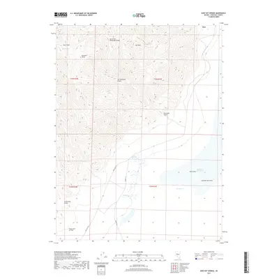
2018 Map of Dixie Hot Springs
USGS Topo · Published 2018About this map
Humboldt Salt Marsh dominates the eastern basin of this Churchill County landscape, where the arid valley floor meets the steep ascent of the Stillwater Range. The topography is defined by dramatic elevation shifts, from the high desert floor at Dixie Valley to the heights of Star Peak. Geological history is visibly etched into the terrain by the Fault Scarp of 1954, a significant seismological feature running along the base of the mountains south of Cottonwood Canyon. Water sources are sparse but critical in this environment, represented by geothermal and freshwater points including Dixie Hot Springs, Cold Springs, and the Dixie Meadows. The road network is minimal, with Dixie Valley Rd and Dempsey Ln providing the primary access through this remote portion of Nevada, connecting the small settlement area of Dixie to the surrounding canyons and salt flats.
Find a feature on this map
21 named features on this map. Tap any name to fly to it.
Don’t see what you’re looking for? This feature index may not catch every label — zoom into the map to look around manually.
Map Details
Editions of this 2018 Dixie Hot Springs Map
This is the sole edition of this map. No revisions or reprints were ever made.
Other maps of this area

1908 · Carson Sink
USGS Topo · 1:250,000

1910 · Carson Sink
USGS Topo · 1:250,000

1955 · Millett
USGS Topo · 1:250,000

1957 · Reno
USGS Topo · 1:250,000

1959 · Reno
USGS Topo · 1:250,000

1959 · Millett
USGS Topo · 1:250,000

1960 · Reno
USGS Topo · 1:250,000

1966 · Clan Alpine Ranch
USGS Topo · 1:62,500

1966 · Humboldt Salt Marsh
USGS Topo · 1:62,500

1966 · Dixie Hot Springs
USGS Topo · 1:62,500