
1966 Map of Dixie Hot Springs
USGS Topo · Published 1968About this map
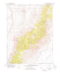
Dixie stands at the edge of the Humboldt Salt Marsh in this 1960s survey of Churchill County. The landscape is defined by the sharp transition from the arid floor of Dixie Valley to the steep canyons of the Stillwater Range. Resource extraction is evident throughout the terrain, with several mining operations including the Buena Vista Mine and Silver Range Mine tucked into the slopes. The presence of Coppereid Ruins and the Anderson Ranch points to a history of ephemeral settlement tied to the region's scattered water sources like Dixie Hot Springs and Eagle Springs. A visible Fault Scarp running along the valley floor highlights the active tectonic nature of this Great Basin environment, where seasonal drainages such as Copper Kettle Canyon and Cottonwood Canyon carve through the mountains toward the Alkali Flat.
Find a feature on this map
39 named features on this map. Tap any name to fly to it.
Don’t see what you’re looking for? This feature index may not catch every label — zoom into the map to look around manually.
Map Details
Editions of this 1966 Dixie Hot Springs Map
2 editions found
Other maps of this area

1908 · Carson Sink
USGS Topo · 1:250,000

1910 · Carson Sink
USGS Topo · 1:250,000

1931 · Lovelock
USGS Topo · 1:250,000

1932 · Sonoma Range
USGS Topo · 1:250,000

1935 · Lovelock
USGS Topo · 1:250,000

1939 · Sonoma Range
USGS Topo · 1:250,000

1954 · Buffalo Mtn
USGS Topo · 1:62,500

1955 · Millett
USGS Topo · 1:250,000

1955 · Lovelock
USGS Topo · 1:250,000

1955 · Winnemucca
USGS Topo · 1:250,000