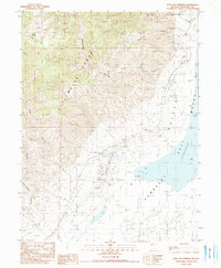
1990 Map of Dixie Hot Springs
USGS Topo · Published 1990About this map
The Stillwater Range dominates this Churchill County landscape, giving way to the vast Humboldt Salt Marsh to the east. This 1990 provisional sheet documents the precarious balance of industry and desert hydrology, featuring the Dixie townsite and the nearby Dixie Hot Springs. The area's complex geology is evidenced by a prominent Fault Scarp and numerous mineral extractions, ranging from the Dixie Comstock Mine to more modern ventures like a Geo Thermal Well and an Open Pit Mine.
Find a feature on this map
26 named features on this map. Tap any name to fly to it.
Don’t see what you’re looking for? This feature index may not catch every label — zoom into the map to look around manually.
Map Details
Editions of this 1990 Dixie Hot Springs Map
This is the sole edition of this map. No revisions or reprints were ever made.
Other maps of this area

1908 · Carson Sink
USGS Topo · 1:250,000

1910 · Carson Sink
USGS Topo · 1:250,000

1955 · Millett
USGS Topo · 1:250,000

1957 · Reno
USGS Topo · 1:250,000

1959 · Reno
USGS Topo · 1:250,000

1959 · Millett
USGS Topo · 1:250,000

1960 · Reno
USGS Topo · 1:250,000

1966 · Clan Alpine Ranch
USGS Topo · 1:62,500

1966 · Humboldt Salt Marsh
USGS Topo · 1:62,500

1966 · Dixie Hot Springs
USGS Topo · 1:62,500