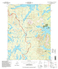
1994 Map of Dixon Entrance D-1
USGS Topo · Published 1998About this map
The South Prince of Wales Wilderness dominates the western portion of this terrain, defined by a jagged coastline of inlets and narrow channels. In the southeast, Kendrick Bay and Mc Lean Arm reach deep into the interior of the island, while the South Arm of Moira Sound carves a long path north through the Tongass National Forest. Inland, the landscape rises toward Bokan Mountain, where a labeled Mine and Gaging Station indicate localized industrial activity amidst the dense topography.
Find a feature on this map
38 named features on this map. Tap any name to fly to it.
Don’t see what you’re looking for? This feature index may not catch every label — zoom into the map to look around manually.
Map Details
Editions of this 1994 Dixon Entrance D-1 Map
This is the sole edition of this map. No revisions or reprints were ever made.
Other maps of this area

1948 · Dixon Entrance D-2
USGS Topo · 1:63,360

1948 · Prince Rupert D-6
USGS Topo · 1:63,360

1948 · Dixon Entrance C-1
USGS Topo · 1:63,360

1948 · Ketchikan A-6
USGS Topo · 1:63,360

1948 · Craig A-1
USGS Topo · 1:63,360

1948 · Dixon Entrance D-1
USGS Topo · 1:63,360

1948 · Craig A-2
USGS Topo · 1:63,360

1951 · Prince Rupert
USGS Topo · 1:250,000

1951 · Dixon Entrance
USGS Topo · 1:250,000

1951 · Dixon Entrance D-2
USGS Topo · 1:63,360