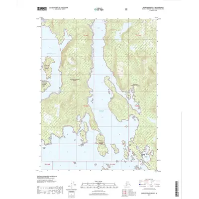
2017 Map of Dixon Entrance D-2 NE
USGS Topo · Published 2017About this map
Prince of Wales Island dominates this maritime landscape along the western reaches of the Tongass National Forest. The map documents a heavily indented coastline where the Gulf of Alaska meets protected waterways like Klakas Inlet and Klakwan Cove. These natural harbors and shoreline features define the region's historical character, characterized by maritime navigation and the timber resources of the surrounding forest. Notable landmarks such as Shipwreck Point, Grave Point, and Davidson Point provide essential orientation for the area's intricate network of islands, including Kassa Island and Klakas Island. The placement of Ruth Island within Ruth Bay further illustrates the complex coastal geography that has long influenced transportation and settlement patterns in this remote corner of Southeast Alaska.
Find a feature on this map
25 named features on this map. Tap any name to fly to it.
Don’t see what you’re looking for? This feature index may not catch every label — zoom into the map to look around manually.
Map Details
Editions of this 2017 Dixon Entrance D-2 NE Map
This is the sole edition of this map. No revisions or reprints were ever made.
Other maps of this area

1948 · Dixon Entrance D-2
USGS Topo · 1:63,360

1948 · Craig A-1
USGS Topo · 1:63,360

1948 · Dixon Entrance D-1
USGS Topo · 1:63,360

1948 · Craig A-2
USGS Topo · 1:63,360

1951 · Dixon Entrance
USGS Topo · 1:250,000

1951 · Dixon Entrance D-2
USGS Topo · 1:63,360

1951 · Craig A-2
USGS Topo · 1:63,360

1957 · Craig
USGS Topo · 1:250,000

1959 · Dixon Entrance
USGS Topo · 1:250,000
1994 · Dixon Entrance D-1
USGS Topo · 1:63,360