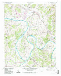
1994 Map of Dixon Springs
USGS Topo · Published 1997About this map
The Cumberland River carves a winding course through central Smith County, defining the landscape with dramatic oxbows like Kennys Bend, Beasleys Bend, and Cages Bend. By the mid-1990s, this stretch of the river had transitioned into the waters of Old Hickory Lake, a reservoir that reshaped the valley's character while leaving historic riverine landforms such as Alexander Island and Lovells Island prominent. Along the banks and ridges, numerous family-named landmarks and cemeteries, including the Piper-Hughes Cem and Manning-Denton Cem, reflect the deep roots of the local farming community.
Find a feature on this map
76 named features on this map. Tap any name to fly to it.
Don’t see what you’re looking for? This feature index may not catch every label — zoom into the map to look around manually.
Map Details
Editions of this 1994 Dixon Springs Map
This is the sole edition of this map. No revisions or reprints were ever made.
Other maps of this area

1928 · Gordonsville
USGS Topo · 1:62,500

1932 · Carthage
USGS Topo · 1:62,500

1942 · Statesville
USGS Topo · 1:100,000

1956 · Corbin
USGS Topo · 1:250,000

1956 · Nashville
USGS Topo · 1:250,000

1958 · New Middleton
USGS Topo · 1:24,000

1958 · Corbin
USGS Topo · 1:250,000

1958 · Bellwood
USGS Topo · 1:24,000

1958 · Dixon Springs
USGS Topo · 1:24,000
1958 · Shop Springs
USGS Topo · 1:24,000