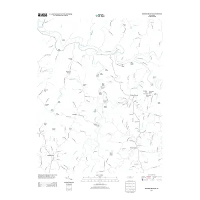
2013 Map of Dodson Branch
USGS Topo · Published 2013About this map
Dodson Branch and the surrounding Jackson County terrain are defined by the winding course of the Roaring River and its numerous tributaries. In the early 21st century, this landscape remains a complex network of named hollows and ridges, such as Seth Hollow and Sugartown Ridge, reflecting a long history of family-based settlement. Significant water features like The Boils and Dry Creek Falls punctuate the drainage basins of the Blackburn Fork and Morrison Creek. The rural community structure is visible through localized centers like Center Grove, Freewill, and Mount Union. Local infrastructure is anchored by landmarks like the Gentry School Rd area and Hensley Cemetery Ln, while the northwestern corner of the map reaches the edges of the Cordell Hull- Reservoir. This map preserves the intricate place-names of a region where the geography of the Cumberland Plateau transition is deeply tied to the specific naming of every hill and creek.
Find a feature on this map
175 named features on this map. Tap any name to fly to it.
Don’t see what you’re looking for? This feature index may not catch every label — zoom into the map to look around manually.
Map Details
Editions of this 2013 Dodson Branch Map
This is the sole edition of this map. No revisions or reprints were ever made.
Other maps of this area

1897 · Standingstone
USGS Topo · 1:125,000

1898 · Standingstone
USGS Topo · 1:125,000

1925 · Gainesboro
USGS Topo · 1:62,500

1929 · Gainesboro
USGS Topo · 1:62,500

1943 · Cookeville
USGS Topo · 1:100,000

1944 · Cookeville
USGS Topo · 1:100,000

1951 · Windle
USGS Topo · 1:24,000

1953 · Cookeville East
USGS Topo · 1:24,000

1953 · Cookeville West
USGS Topo · 1:24,000
1955 · Hilham
USGS Topo · 1:24,000