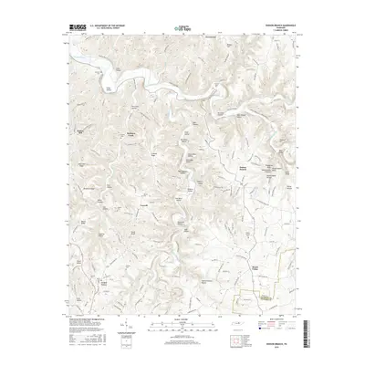
2016 Map of Dodson Branch
USGS Topo · Published 2016About this map
Roaring River meanders across the northern portion of this Jackson County landscape, passing through a deeply dissected plateau where the Blackburn Fork and Morrison Creek have carved intricate valley systems. The terrain is characterized by dozens of family-named hollows and ridges, such as Seth Hollow, Tom Allen Hollow, and Backbone Ridge, reflecting a long history of local settlement and land use. Small communities like Dodson Branch, Center Grove, and Freewill anchor the high ground between these drainages. Genealogists will find a wealth of specific burial sites scattered throughout the area, including Stafford Cem, Twelve Corners Cem, and the Birdwell Cem. Notable landmarks such as Hardscrabble Pinnacle and The Boils highlight the unique geomorphology of the Tennessee Highland Rim transition.
Find a feature on this map
166 named features on this map. Tap any name to fly to it.
Don’t see what you’re looking for? This feature index may not catch every label — zoom into the map to look around manually.
Map Details
Editions of this 2016 Dodson Branch Map
This is the sole edition of this map. No revisions or reprints were ever made.
Other maps of this area

1897 · Standingstone
USGS Topo · 1:125,000

1898 · Standingstone
USGS Topo · 1:125,000

1925 · Gainesboro
USGS Topo · 1:62,500

1929 · Gainesboro
USGS Topo · 1:62,500

1943 · Cookeville
USGS Topo · 1:100,000

1944 · Cookeville
USGS Topo · 1:100,000

1951 · Windle
USGS Topo · 1:24,000

1953 · Cookeville East
USGS Topo · 1:24,000

1953 · Cookeville West
USGS Topo · 1:24,000
1955 · Hilham
USGS Topo · 1:24,000