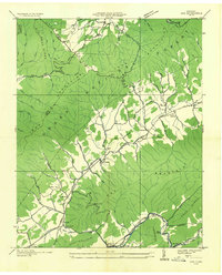
1935 Map of Doe
USGS Topo · Published 1935About this map
Doe Mountain and the Iron Mountains dominate this 1935 landscape, where the Tennessee Valley Authority documented the rural communities of Johnson and Carter counties. The settlement of Doeville serves as a local hub, featuring the Doeville Sch and the Doeville P O Doe Station. The map illustrates a mountainous society organized around water gaps and ridges, with numerous small schools like Bethel Sch and Pine Orchard Sch serving isolated hollows.
Find a feature on this map
72 named features on this map. Tap any name to fly to it.
Don’t see what you’re looking for? This feature index may not catch every label — zoom into the map to look around manually.
Map Details
Editions of this 1935 Doe Map
This is the sole edition of this map. No revisions or reprints were ever made.
Other maps of this area

1891 · Roan Mountain
USGS Topo · 1:125,000

1891 · Abingdon
USGS Topo · 1:125,000

1893 · Cranberry
USGS Topo · 1:125,000

1894 · Roan Mountain
USGS Topo · 1:125,000

1894 · Abingdon
USGS Topo · 1:125,000

1895 · Cranberry
USGS Topo · 1:125,000

1897 · Bristol
USGS Topo · 1:125,000

1899 · Cranberry
USGS Topo · 1:125,000

1902 · Bristol
USGS Topo · 1:125,000

1902 · Cranberry
USGS Topo · 1:125,000