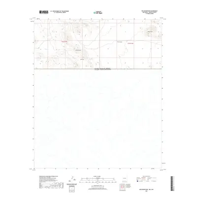
2020 Map of Dog Mountains
USGS Topo · Published 2020About this map
The United States Of America Estados Unidos Mexicanos international boundary bisects this remote portion of Hidalgo County, New Mexico. The northern half of the quadrangle is dominated by the high-elevation terrain of the Dog Mountains, where the landscape transitions from the open expanse of Deer Flat to the prominent heights of Haystack Mtn. This arid environment is defined by seasonal drainage patterns, such as Willow Cr, which cut through the steep topography.
Find a feature on this map
8 named features on this map. Tap any name to fly to it.
Don’t see what you’re looking for? This feature index may not catch every label — zoom into the map to look around manually.
Map Details
Editions of this 2020 Dog Mountains Map
This is the sole edition of this map. No revisions or reprints were ever made.
Other maps of this area

1918 · Dog Mountains
USGS Topo · 1:62,500

1955 · Douglas
USGS Topo · 1:250,000

1959 · Douglas
USGS Topo · 1:250,000

1961 · Douglas
USGS Topo · 1:250,000

1964 · Douglas
USGS Topo · 1:250,000
1982 · Pierce Peak
USGS Topo · 1:24,000
1982 · Sentinel Butte
USGS Topo · 1:24,000
1983 · Dog Mountains
USGS Topo · 1:24,000
1983 · Alamo Hueco Mountains
USGS Topo · 1:100,000
1983 · Campbell Well
USGS Topo · 1:24,000