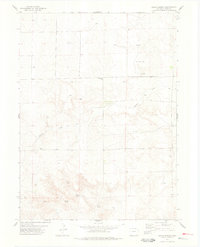
1977 Map of Dolan Spring
USGS Topo · Published 1978About this map
Dolan Spring and its surrounding high plains landscape in Weld County define this 1970s topographic study. The area is characterized by several natural water sources clustered in the south, including Deer Spring, Willow Spring, and Hillman Spring, which suggest the historic importance of reliable water in this arid stretch of the Colorado-Wyoming borderlands. Evidence of land use and resource extraction is scattered throughout the terrain, from an Oil Well and multiple Drill Hole sites to isolated Gravel Pits and a Sample station. Rural life and infrastructure are marked by the presence of Sunnyside Cem in the north and a Radio Tower in the southwest corner. The long, winding path of Sidney Draw cuts diagonally across the center of the sheet, providing a primary drainage feature for the region's undulating topography.
Find a feature on this map
21 named features on this map. Tap any name to fly to it.
Don’t see what you’re looking for? This feature index may not catch every label — zoom into the map to look around manually.
Map Details
Editions of this 1977 Dolan Spring Map
This is the sole edition of this map. No revisions or reprints were ever made.
Other maps of this area

1954 · Sterling
USGS Topo · 1:250,000

1954 · Scottsbluff
USGS Topo · 1:250,000

1954 · Cheyenne
USGS Topo · 1:250,000

1954 · Greeley
USGS Topo · 1:250,000

1957 · Greeley
USGS Topo · 1:250,000

1958 · Cheyenne
USGS Topo · 1:250,000

1958 · Greeley
USGS Topo · 1:250,000

1958 · Scottsbluff
USGS Topo · 1:250,000

1958 · Sterling
USGS Topo · 1:250,000

1961 · Greeley
USGS Topo · 1:250,000