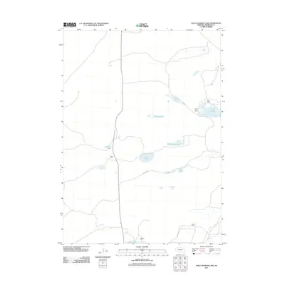
2011 Map of Dolly Warden Lake
USGS Topo · Published 2011About this map
Dolly Warden Lake and a series of smaller alkali and freshwater basins define this sparsely settled portion of the Nebraska Sandhills. In the early 21st century, the landscape remains dominated by large ranching operations, such as the Peterson Ranch and the family-held J Sandoz Ranch and F Sandoz Ranch. These holdings are connected by a thin network of unpaved tracks, including Ostrander Rd and Sandoz Grave Rd, which follow the natural contours between the dunes and depressions.
Find a feature on this map
15 named features on this map. Tap any name to fly to it.
Don’t see what you’re looking for? This feature index may not catch every label — zoom into the map to look around manually.
Map Details
Editions of this 2011 Dolly Warden Lake Map
This is the sole edition of this map. No revisions or reprints were ever made.
Other maps of this area

1948 · Twin Lakes
USGS Topo · 1:62,500

1948 · Spade Ranch
USGS Topo · 1:62,500

1950 · Twin Lakes
USGS Topo · 1:62,500

1950 · Spade Ranch
USGS Topo · 1:62,500

1955 · Alliance
USGS Topo · 1:250,000

1957 · Alliance
USGS Topo · 1:250,000

1958 · Alliance
USGS Topo · 1:250,000

1969 · Rushville 4 SW
USGS Topo · 1:24,000

1969 · Rushville SE
USGS Topo · 1:24,000
1969 · Rushville 4 SE
USGS Topo · 1:24,000