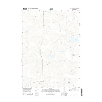
2014 Map of Dolly Warden Lake
USGS Topo · Published 2014About this map
Dolly Warden Lake and its surrounding water bodies define this high-plains landscape in eastern Sheridan County. The terrain is characterized by numerous small basins and depressions that hold water, creating a scattered network of lakes including Petes Lake, Spring Lake, and Chicken Lake. This hydrologic pattern suggests a delicate environmental balance typical of the Nebraska Sandhills region, where groundwater and surface features are closely linked. Modern accessibility is provided by Ne-27, which runs north-south through the center of the sheet, and a network of rural trails such as 377th Trl and 448th Trl. Low-lying areas like Willow Valley break the topography, while other named basins such as Round Lake, Keys Lake, and Sandoz Lake offer clear reference points for land use and navigation in this section of the Great Plains.
Find a feature on this map
17 named features on this map. Tap any name to fly to it.
Don’t see what you’re looking for? This feature index may not catch every label — zoom into the map to look around manually.
Map Details
Editions of this 2014 Dolly Warden Lake Map
This is the sole edition of this map. No revisions or reprints were ever made.
Other maps of this area

1948 · Twin Lakes
USGS Topo · 1:62,500

1948 · Spade Ranch
USGS Topo · 1:62,500

1950 · Twin Lakes
USGS Topo · 1:62,500

1950 · Spade Ranch
USGS Topo · 1:62,500

1955 · Alliance
USGS Topo · 1:250,000

1957 · Alliance
USGS Topo · 1:250,000

1958 · Alliance
USGS Topo · 1:250,000

1969 · Rushville 4 SW
USGS Topo · 1:24,000

1969 · Rushville SE
USGS Topo · 1:24,000
1969 · Rushville 4 SE
USGS Topo · 1:24,000