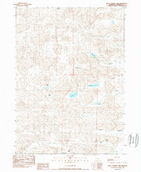
1989 Map of Dolly Warden Lake
USGS Topo · Published 1989About this map
The Mari Sandoz Museum stands near the northern boundary of this high plains landscape, anchoring a region deeply tied to the Sandoz family legacy. This 1989 survey reveals a Sandhills environment defined by an intricate network of localized basins and ranching outposts. Family-named landmarks such as E Sandoz Ranch, J Sandoz Ranch, and the Petersen Ranch illustrate the traditional land use patterns of Sheridan County, while the scattered waters of Dolly Warden Lake, Sandoz Lake, and Petes Lake provide critical resources in this arid terrain.
Find a feature on this map
22 named features on this map. Tap any name to fly to it.
Don’t see what you’re looking for? This feature index may not catch every label — zoom into the map to look around manually.
Map Details
Editions of this 1989 Dolly Warden Lake Map
This is the sole edition of this map. No revisions or reprints were ever made.
Other maps of this area

1948 · Twin Lakes
USGS Topo · 1:62,500

1948 · Spade Ranch
USGS Topo · 1:62,500

1950 · Twin Lakes
USGS Topo · 1:62,500

1950 · Spade Ranch
USGS Topo · 1:62,500

1955 · Alliance
USGS Topo · 1:250,000

1957 · Alliance
USGS Topo · 1:250,000

1958 · Alliance
USGS Topo · 1:250,000

1969 · Rushville 4 SW
USGS Topo · 1:24,000

1969 · Rushville SE
USGS Topo · 1:24,000
1969 · Rushville 4 SE
USGS Topo · 1:24,000