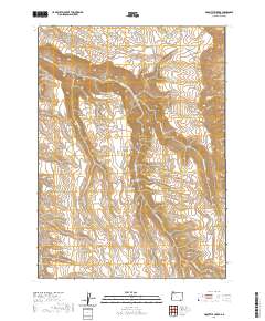
2020 Map of Doolittle Creek
USGS Topo · Published 2020About this map
The Oregon Canyon Mountains dominate this high-desert landscape in Malheur County, where water sources dictate the geography of human activity. Dozens of named springs and small reservoirs, such as Buckaroo Corral Spring, Sheep Corral Spring, and Snowberry Reservoir, suggest a history of seasonal ranching and livestock management. This network of vital water points is connected by remote corridors like Fifteenmile Reservoir Rd, which skirts the southern edge of the mountains. The terrain is deeply incised by drainages including Whitehorse Cr and Cottonwood Cr, leading to the ominously named Death Trap canyon. Landmarks like Twin Peaks and Doolittle Cr provide essential navigational points in this arid expanse of the Great Basin, reflecting a landscape where geographic names often signify either a vital resource or a specific topographical hazard.
Find a feature on this map
34 named features on this map. Tap any name to fly to it.
Don’t see what you’re looking for? This feature index may not catch every label — zoom into the map to look around manually.
Map Details
Editions of this 2020 Doolittle Creek Map
This is the sole edition of this map. No revisions or reprints were ever made.
Other maps of this area

1955 · Jordan Valley
USGS Topo · 1:250,000

1955 · Adel
USGS Topo · 1:250,000

1957 · Adel
USGS Topo · 1:250,000

1957 · Jordan Valley
USGS Topo · 1:250,000

1958 · Adel
USGS Topo · 1:250,000

1958 · Jordan Valley
USGS Topo · 1:250,000

1962 · Adel
USGS Topo · 1:250,000
1981 · Little Whitehorse Creek
USGS Topo · 1:24,000
1981 · Dry Creek Bench
USGS Topo · 1:24,000
1981 · Doolittle Creek
USGS Topo · 1:24,000