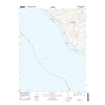
2015 Map of Double Point
USGS Topo · Published 2015About this map
Point Reyes National Seashore defines this coastal landscape where the land meets the Pacific Ocean along the dramatic Marin County shoreline. The topography is shaped by the presence of the San Andreas Fault, which runs through the northeastern corner of the map near Olema Cr and Mill Pond. This specific quadrangle reveals a complex series of coastal freshwater lakes, including Wildcat Lake, Pelican Lake, and Bass Lake, situated just inland from the steep bluffs. Further south, Double Point and Stormy Stack mark the transition toward the jagged edges of Abalone Point. Moving north through Bear Valley, the coastline features prominent landmarks like Arch Rock, Keyhole, and Millers Point, illustrating a terrain carved by maritime forces and tectonic activity. The map provides a detailed view of the drainage patterns of Alamere Cr and Coast Cr as they navigate the coastal ridges toward the sea.
Find a feature on this map
27 named features on this map. Tap any name to fly to it.
Don’t see what you’re looking for? This feature index may not catch every label — zoom into the map to look around manually.
Map Details
Editions of this 2015 Double Point Map
This is the sole edition of this map. No revisions or reprints were ever made.
Other maps of this area

1897 · Tamalpais
USGS Topo · 1:62,500

1914 · Petaluma
USGS Topo · 1:62,500

1916 · Point Reyes
USGS Topo · 1:48,000

1918 · Point Reyes
USGS Topo · 1:62,500

1941 · Tamalpais
USGS Topo · 1:62,500

1942 · Petaluma
USGS Topo · 1:62,500

1947 · Santa Rosa
USGS Topo · 1:250,000

1947 · San Francisco
USGS Topo · 1:250,000

1948 · San Francisco
USGS Topo · 1:250,000

1949 · Santa Rosa
USGS Topo · 1:250,000