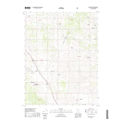
2018 Map of Double Spring
USGS Topo · Published 2018About this map
The settlement of Double Spring occupies a high-desert valley within the eastern reaches of the Toiyabe National Forest. This high-altitude landscape is defined by the sharp topography of the Pine Nut Mountains, where peaks like Bald Mtn, Simee Dimeh Summit, and Granite Peak overlook a network of deep drainages. The area’s hydrology is centered around critical water sources in an otherwise arid environment, specifically the eponymous Double Spring and Buffalo Spring. These springs historically supported transit and grazing across the broad, high basins of Double Spring Flat and Dead Horse Flat. The map reveals a rugged terrain carved by numerous canyons, including Minnehaha Canyon, Mill Canyon, and Blossom Canyon, which suggest a long history of local ranching and seasonal movement through the gaps of the Pine Nut range.
Find a feature on this map
34 named features on this map. Tap any name to fly to it.
Don’t see what you’re looking for? This feature index may not catch every label — zoom into the map to look around manually.
Map Details
Editions of this 2018 Double Spring Map
This is the sole edition of this map. No revisions or reprints were ever made.
Other maps of this area

1889 · Markleeville
USGS Topo · 1:125,000

1891 · Markleeville
USGS Topo · 1:125,000

1891 · Wellington
USGS Topo · 1:125,000

1893 · Markleeville
USGS Topo · 1:125,000

1893 · Wellington
USGS Topo · 1:125,000

1948 · Walker Lake
USGS Topo · 1:250,000

1956 · Desert Creek Peak
USGS Topo · 1:62,500

1956 · Topaz Lake
USGS Topo · 1:62,500

1957 · Walker Lake
USGS Topo · 1:250,000

1957 · Wellington
USGS Topo · 1:62,500