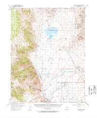
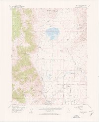
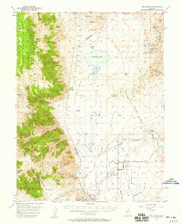
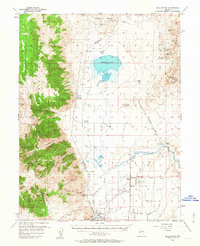
1957 Map of Wellington
USGS Topo · Published 1957About this map
The agricultural and mining heritage of Smith Valley is centered here between the Pine Nut Mountains and the Singatse Range. In the late 1950s, the irrigation network defining this landscape is clearly visible, with the Colony Ditch, Plymouth Canal, and Saroni Canal drawing water from the West Walker River to support settlements like Wellington and Smith. To the north, Artesia Lake and the Honker Duck Club sit below the Buckskin Range, while the surrounding slopes are dotted with industrial sites including the Ludwig Mine and Douglas Hill Mine. Traces of earlier infrastructure appear as an Old Railroad Grade and former town locations such as Delphi (Site) and Hudson (Site), providing essential evidence for researchers tracing the transition from early mining camps to the established ranching community of the mid-twentieth century.
Find a feature on this map
57 named features on this map. Tap any name to fly to it.
Don’t see what you’re looking for? This feature index may not catch every label — zoom into the map to look around manually.
Map Details
Editions of this 1957 Wellington Map
4 editions found
Other maps of this area

1889 · Markleeville
USGS Topo · 1:125,000

1891 · Carson
USGS Topo · 1:125,000

1891 · Markleeville
USGS Topo · 1:125,000

1891 · Wabuska
USGS Topo · 1:125,000

1891 · Wellington
USGS Topo · 1:125,000

1893 · Carson
USGS Topo · 1:125,000

1893 · Markleeville
USGS Topo · 1:125,000

1893 · Wellington
USGS Topo · 1:125,000

1894 · Wabuska
USGS Topo · 1:125,000

1948 · Walker Lake
USGS Topo · 1:250,000