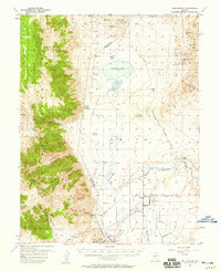
1957 Map of Wellington
USGS Topo · Published 1959About this map
Smith Valley and its surrounding mountain ranges define this mid-century landscape on the border of Lyon and Douglas Counties. The valley floor is heavily influenced by water management, featuring an intricate network of irrigation infrastructure such as the Saroni Canal, Plymouth Canal, and Colony Ditch that tap into the West Walker River. Settlement centers around Smith and Wellington, with smaller agricultural and recreational outposts like Artesia Ranch and the Honker Duck Club situated near the seasonally shifting Artesia Lake.
Find a feature on this map
57 named features on this map. Tap any name to fly to it.
Don’t see what you’re looking for? This feature index may not catch every label — zoom into the map to look around manually.
Map Details
Editions of this 1957 Wellington Map
4 editions found

Other maps of this area

1889 · Markleeville
USGS Topo · 1:125,000

1891 · Carson
USGS Topo · 1:125,000

1891 · Markleeville
USGS Topo · 1:125,000

1891 · Wabuska
USGS Topo · 1:125,000

1891 · Wellington
USGS Topo · 1:125,000

1893 · Carson
USGS Topo · 1:125,000

1893 · Markleeville
USGS Topo · 1:125,000

1893 · Wellington
USGS Topo · 1:125,000

1894 · Wabuska
USGS Topo · 1:125,000

1948 · Walker Lake
USGS Topo · 1:250,000