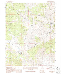
1986 Map of Double Spring
USGS Topo · Published 1987About this map
The Pine Nut Mountains dominate this high-desert landscape in Douglas County, revealing a mid-1980s look at a region defined by its silver and gold mining heritage. Numerous claims and historic sites are peppered across the slopes, including Bullionville and the Ruby Hill Mine in the north, while the Gold Bug Mine and Longfellow Mine sit perched near the higher elevations of Bald Mountain. The presence of these named shafts alongside countless unnamed prospects indicates the intense mineral exploration that once pulsed through the canyons.
Find a feature on this map
33 named features on this map. Tap any name to fly to it.
Don’t see what you’re looking for? This feature index may not catch every label — zoom into the map to look around manually.
Map Details
Editions of this 1986 Double Spring Map
This is the sole edition of this map. No revisions or reprints were ever made.
Other maps of this area

1889 · Markleeville
USGS Topo · 1:125,000

1891 · Markleeville
USGS Topo · 1:125,000

1891 · Wellington
USGS Topo · 1:125,000

1893 · Markleeville
USGS Topo · 1:125,000

1893 · Wellington
USGS Topo · 1:125,000

1948 · Walker Lake
USGS Topo · 1:250,000

1956 · Desert Creek Peak
USGS Topo · 1:62,500

1956 · Topaz Lake
USGS Topo · 1:62,500

1957 · Walker Lake
USGS Topo · 1:250,000

1957 · Wellington
USGS Topo · 1:62,500