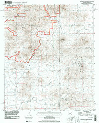
1998 Map of Doubtful Canyon
USGS Topo · Published 2003About this map
Butterfield Trail cuts through this high desert terrain along the border of Cochise County, Arizona, and Hidalgo County, New Mexico. The map records a landscape of rugged isolation where historic transportation routes and small-scale mining intersect. High points like Steins Peak and the Roostercomb overlook a network of drainage systems including Doubtful Canyon and Little Doubtful Canyon. The eastern portion of the quadrangle shows a concentrated cluster of industrial activity with the Volcano Mine, Flora Mine, and National Mine all situated near the modern state boundary. Evidence of early travel and settlement is sparse but significant, marked by a lone Grave near the trail and essential water sources such as Ward Spring, Canteen Spring, and Dean Tank. This 1998 survey documents the remote nature of the Peloncillo Mountains Wilderness, preserving the location of numerous unnamed Mine Shafts and Prospects scattered among the peaks.
Find a feature on this map
26 named features on this map. Tap any name to fly to it.
Don’t see what you’re looking for? This feature index may not catch every label — zoom into the map to look around manually.
Map Details
Editions of this 1998 Doubtful Canyon Map
This is the sole edition of this map. No revisions or reprints were ever made.
Other maps of this area

1917 · San Simon
USGS Topo · 1:125,000

1926 · Orange Butte
USGS Topo · 1:62,500

1928 · Chenoweth
USGS Topo · 1:62,500

1950 · San Simon
USGS Topo · 1:62,500

1950 · Vanar
USGS Topo · 1:62,500

1951 · Vanar
USGS Topo · 1:62,500

1951 · San Simon
USGS Topo · 1:62,500

1954 · Silver City
USGS Topo · 1:250,000

1958 · Silver City
USGS Topo · 1:250,000

1962 · Silver City
USGS Topo · 1:250,000