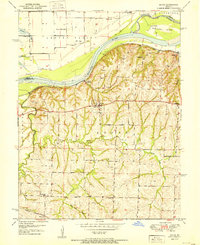
1951 Map of Dover
USGS Topo · Published 1951About this map
Dover sits atop the bluff line south of the Missouri River, serving as a focal point for this 1951 topographic survey of rural Lafayette County. The landscape is defined by the sharp transition from the flat river bottomlands, containing Baltimore Island, to the deeply dissected hills to the south. This rugged topography is drained by a network of waterways including Little Tabo Creek, Cottonwood Creek, and the Rocky Ford Branch, which cut through the agricultural terrain.
Find a feature on this map
25 named features on this map. Tap any name to fly to it.
Don’t see what you’re looking for? This feature index may not catch every label — zoom into the map to look around manually.
Map Details
Editions of this 1951 Dover Map
2 editions found
Other maps of this area

1889 · Lexington
USGS Topo · 1:125,000

1949 · Mayview
USGS Topo · 1:24,000

1949 · Lexington East
USGS Topo · 1:24,000

1950 · Lexington East
USGS Topo · 1:24,000

1950 · Mayview
USGS Topo · 1:24,000

1950 · Dover
USGS Topo · 1:24,000

1951 · Alma
USGS Topo · 1:24,000
1951 · Higginsville
USGS Topo · 1:24,000

1951 · Waverly
USGS Topo · 1:24,000

1953 · Moberly
USGS Topo · 1:250,000