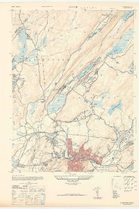
1947 Map of Dover
USGS Topo · Published 1947About this map
Dover and Wharton stand as the industrial and residential hubs of this mid-century landscape, positioned along the busy Rockaway River. The presence of the Morris Canal and the Central Railroad of New Jersey underscores a legacy of transport and commerce that shaped these communities. Northward, the terrain transitions into a more recreation-focused geography, dominated by the eastern edge of Lake Hopatcong and the Camp Ranger for Boys near Woodport.
Find a feature on this map
60 named features on this map. Tap any name to fly to it.
Don’t see what you’re looking for? This feature index may not catch every label — zoom into the map to look around manually.
Map Details
Editions of this 1947 Dover Map
This is the sole edition of this map. No revisions or reprints were ever made.
Other maps of this area

1888 · Franklin
USGS Topo · 1:62,500

1888 · Morristown
USGS Topo · 1:62,500

1888 · Lake Hopatcong
USGS Topo · 1:62,500

1891 · Greenwood Lake
USGS Topo · 1:62,500

1893 · Greenwood Lake
USGS Topo · 1:62,500

1894 · Morristown
USGS Topo · 1:62,500

1894 · Lake Hopatcong
USGS Topo · 1:62,500

1894 · Franklin
USGS Topo · 1:62,500

1897 · Franklin
USGS Topo · 1:62,500

1898 · Lake Hopatcong
USGS Topo · 1:62,500