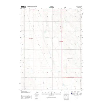
2013 Map of Dover
USGS Topo · Published 2013About this map
Pawnee National Grassland dominates the eastern landscape of this Weld County region, where the high plains terrain is defined by a sparse network of intermittent drainage and essential water management. The settlement of Dover sits at a crossroads of the section-line road system, serving as a focal point for the surrounding ranching and agricultural lands. Water resources are critical in this arid environment, evidenced by the presence of the Giffon Number 1 Reservoir, Giffon Number 2 Reservoir, and Dover Reservoir. These man-made features support the local ecology and economy alongside natural watercourses like Lone Tree Creek and Little Owl Creek. The map documents a meticulously surveyed landscape, with a rigid grid of county roads such as CO Road 114 and CO Road 27 providing access across the expansive grassland flats.
Find a feature on this map
31 named features on this map. Tap any name to fly to it.
Don’t see what you’re looking for? This feature index may not catch every label — zoom into the map to look around manually.
Map Details
Editions of this 2013 Dover Map
This is the sole edition of this map. No revisions or reprints were ever made.
Other maps of this area

1908 · Eaton
USGS Topo · 1:125,000

1910 · Eaton
USGS Topo · 1:125,000

1954 · Greeley
USGS Topo · 1:250,000

1957 · Greeley
USGS Topo · 1:250,000

1958 · Greeley
USGS Topo · 1:250,000
1960 · Cobb Lake
USGS Topo · 1:24,000
1960 · Nunn
USGS Topo · 1:24,000
1960 · Antelope Reservoir
USGS Topo · 1:24,000

1961 · Greeley
USGS Topo · 1:250,000

1964 · Greeley
USGS Topo · 1:250,000