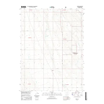
2016 Map of Dover
USGS Topo · Published 2016About this map
Dover occupies a central position on this high plains landscape, situated within a grid of county roads that define the rural character of Weld County. The drainage patterns of Lone Tree Cr and Little Owl Cr suggest the natural hydrology of the region, while the presence of the Giffon Number 1 Reservoir, Giffon Number 2 Reservoir, and Dover Reservoir highlights the critical role of water management in this arid environment. The eastern portion of the survey is dominated by the Pawnee National Grassland, reflecting a shift from agricultural land use to federally protected prairie. This map provides a detailed view of the township and range system, showing the precise layout of sections across T10N R66W and surrounding areas, useful for researchers tracing land ownership or the development of rural infrastructure in northern Colorado.
Find a feature on this map
30 named features on this map. Tap any name to fly to it.
Don’t see what you’re looking for? This feature index may not catch every label — zoom into the map to look around manually.
Map Details
Editions of this 2016 Dover Map
This is the sole edition of this map. No revisions or reprints were ever made.
Other maps of this area

1908 · Eaton
USGS Topo · 1:125,000

1910 · Eaton
USGS Topo · 1:125,000

1954 · Greeley
USGS Topo · 1:250,000

1957 · Greeley
USGS Topo · 1:250,000

1958 · Greeley
USGS Topo · 1:250,000
1960 · Cobb Lake
USGS Topo · 1:24,000
1960 · Nunn
USGS Topo · 1:24,000
1960 · Antelope Reservoir
USGS Topo · 1:24,000

1961 · Greeley
USGS Topo · 1:250,000

1964 · Greeley
USGS Topo · 1:250,000