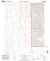
1997 Map of Dover
USGS Topo · Published 2000About this map
Dover serves as the focal point of this northern Colorado landscape, situated along the drainages of Lone Tree Creek and Little Owl Creek. The map detail captures the specialized land use of the High Plains during the late twentieth century, dominated by the Pawnee National Grassland and the Central Plains Experimental Range. This intersection of conservation and agricultural science is highlighted by the presence of the Pawnee National Grasslands Research Center, reflecting the region's importance in rangeland studies. Aside from these institutional markers, the terrain is defined by a network of intermittent streams like Spring Creek and several Gravel Pits, illustrating a landscape shaped by both natural water cycles and local resource extraction. Numerous water tanks dot the map, indicating the continued reliance on managed water sources for ranching operations in this arid environment.
Find a feature on this map
11 named features on this map. Tap any name to fly to it.
Don’t see what you’re looking for? This feature index may not catch every label — zoom into the map to look around manually.
Map Details
Editions of this 1997 Dover Map
This is the sole edition of this map. No revisions or reprints were ever made.
Other maps of this area

1908 · Eaton
USGS Topo · 1:125,000

1910 · Eaton
USGS Topo · 1:125,000

1954 · Greeley
USGS Topo · 1:250,000

1957 · Greeley
USGS Topo · 1:250,000

1958 · Greeley
USGS Topo · 1:250,000
1960 · Cobb Lake
USGS Topo · 1:24,000
1960 · Nunn
USGS Topo · 1:24,000
1960 · Antelope Reservoir
USGS Topo · 1:24,000

1961 · Greeley
USGS Topo · 1:250,000

1964 · Greeley
USGS Topo · 1:250,000