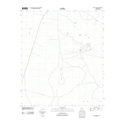
2010 Map of Doyle Peak
USGS Topo · Published 2010About this map
Mining operations dot the arid landscape of the Apache Hills in this southwestern corner of New Mexico during the early 2000s. The concentration of claims such as the Last Chance Lode, Summertime Mine, and Chapo Mine suggests a terrain defined by historical mineral prospecting and extraction. These sites are situated east of the broad Hachita Valley, where the land rises sharply toward peaks and ridges.
Find a feature on this map
16 named features on this map. Tap any name to fly to it.
Don’t see what you’re looking for? This feature index may not catch every label — zoom into the map to look around manually.
Map Details
Editions of this 2010 Doyle Peak Map
This is the sole edition of this map. No revisions or reprints were ever made.
Other maps of this area

1918 · Big Hatchet Peak
USGS Topo · 1:62,500

1918 · Hachita
USGS Topo · 1:62,500

1918 · Victorio
USGS Topo · 1:62,500

1955 · Douglas
USGS Topo · 1:250,000

1959 · Douglas
USGS Topo · 1:250,000

1961 · Douglas
USGS Topo · 1:250,000

1964 · Douglas
USGS Topo · 1:250,000
1964 · Hat Top Mountain
USGS Topo · 1:24,000
1965 · Victorio Ranch
USGS Topo · 1:24,000
1982 · Doyle Peak
USGS Topo · 1:24,000