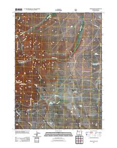
2011 Map of Drake Peak
USGS Topo · Published 2011About this map
Drake Peak and the surrounding high desert terrain of Lake County define this landscape, where water management is central to the area's utility. The presence of the Deboy Ranch and Vinyard Cabin indicates a history of livestock ranching and seasonal habitation in a region primarily shaped by its drainage networks. Systems of creeks including McDowell Creek, Drake Creek, and Twelvemile Creek are supplemented by man-made infrastructure such as Flynn Dam and Flynn Reservoir, along with the State Game Reservoir Number Two. These features illustrate the vital role of water storage for both agricultural ranching and wildlife management in the Oregon interior. To the south, Pedders Ridge and Irish Hill rise above the drainage of Pedders Creek and the shores of Thompson Lake, marking the transition between the watershed basins and the elevated peaks of the Warner Mountains.
Find a feature on this map
26 named features on this map. Tap any name to fly to it.
Don’t see what you’re looking for? This feature index may not catch every label — zoom into the map to look around manually.
Map Details
Editions of this 2011 Drake Peak Map
This is the sole edition of this map. No revisions or reprints were ever made.
Other maps of this area

1955 · Klamath Falls
USGS Topo · 1:250,000

1955 · Adel
USGS Topo · 1:250,000

1957 · Adel
USGS Topo · 1:250,000

1958 · Klamath Falls
USGS Topo · 1:250,000

1958 · Adel
USGS Topo · 1:250,000

1962 · Adel
USGS Topo · 1:250,000

1967 · Plush
USGS Topo · 1:24,000

1967 · Priday Reservoir
USGS Topo · 1:24,000
1968 · Sage Hen Butte
USGS Topo · 1:24,000

1968 · Crook Peak
USGS Topo · 1:24,000